
WV 511
Drivers can check road and traffic conditions through:
- Dialing 511
- Downloading the 511 Drive Safe app
- Visiting www.WV511.org
- Following @WV511 on Twitter
24/7 Assistance
Notice: Dial *77 on your mobile phone to reach help at any time.
State Police units and Courtesy Patrol teams respond to disabled vehicles, accidents, and emergency needs across the entire corridor.
Safety Enhancements Along the Turnpike
The roadway includes several safety features designed to educate drivers and reduce incidents.

Variable Message Signs
Placed along the roadway in both directions to alert drivers of delays, weather, construction, and incidents.

8-Inch Edge Lines
Larger than standard lines to improve visibility, especially at night or in adverse weather.

Speed Awareness Trailers
Used to remind motorists of their current speed.

Warning Strips
Rumble strips and snaps run along the entire roadway to help prevent runoff road crashes.

Toll Plaza Safety
- Reduce speed to 35 mph when entering toll zones
- Stop at the booth unless you are paying with E-ZPass or Pay-By-Plate
- Stay alert for workers and patrons crossing lanes
- All lanes support E‑ZPass and Pay‑By‑Plate, but cash and credit are offered in select lanes

General Driving Tips
- No parking or stopping in travel lanes, ramps, or on bridges
- Use caution and follow posted speed limits
- No U-turns
- Do not tailgate
- Buckle your seatbelt
- Use signals when exiting or changing lanes
- Check fluid levels and tire pressure before traveling
- Use caution when merging after toll plazas
Who Keeps You Safe on The Turnpike
West Virginia State Police Troop 7
State Police units are assigned to the Turnpike every hour of every day. Troopers respond to all traffic incidents and are trained in CPR and First Aid. Patrol vehicles are also equipped with Automated External Defibrillators (AEDs) to assist during medical emergencies.
Public Service Commission Enforcement Officers
PSC officers enforce commercial vehicle safety regulations.
Their Work Includes:
- Inspecting trucks and buses
- Monitoring high accident commercial vehicle areas
- Enforcing U.S. Department of Transportation safety standards
- Supporting safe freight movement across the corridor
Parkways Safety Officers
These officers monitor facilities, assess hazards, and help maintain a safe environment for Parkways employees and travelers. They work alongside law enforcement and maintenance teams during incidents and weather events.
Turnpike Courtesy Patrol
This free service operates 24 hours a day, every day of the year.
Courtesy Patrol provides:
- Flat tire changes
- Starts
- Calls for tow services
- A small amount of gasoline
- Minor safety repairs
- Coverage spans the full 88 miles from Charleston to Princeton
Detour Routes
Detour A (I‐77 Exit 59 to Exit 48)
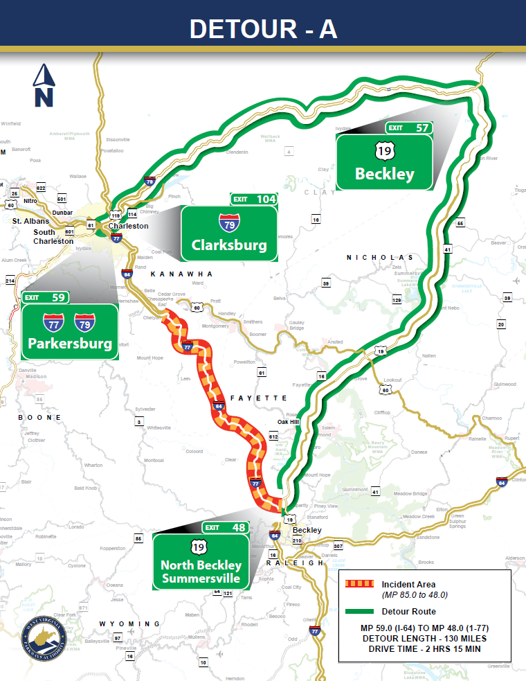
If I‐77 southbound is closed between Exits 85 and 48, traffic will be notified of the closure and, if required, detoured in Charleston onto I‐79 traveling northbound. Detoured drivers will proceed north on I‐79 to Exit 57 and will then be directed to US‐19, where they will travel south to Beckley. From there, drivers may take the Exit 48 entrance ramp to I‐77 and proceed south.
Motorists traveling east on I‐64 will take Exit 59 onto I‐77 north and will be directed onto I‐79 north at Exit 104 (I‐77) interchange. From there, drivers should follow the detour outlined above.
If the northbound lanes of I‐77 are closed between Exits 85 and 44, drivers will be directed to take Exit 48 and continue north on US‐19 to the Exit 57 at the I‐77/US‐19 interchange. From there, drivers will proceed south on I‐79 to the Exit 104 interchange, where they will have the option to proceed north or south on I‐77.
Detour B (I‐77 Exit 96 to Exit 85)
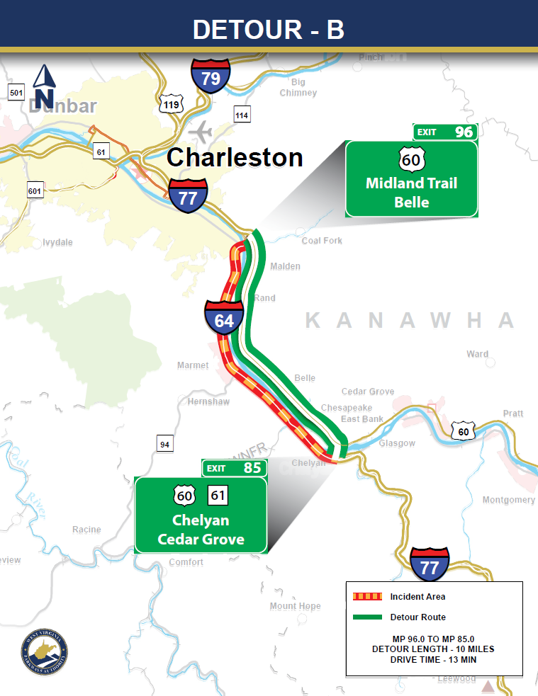
US‐60 will serve as the detour route to bypass I‐77 between Marmet and Chelyan. In the case of a south bound incident, motorists will be detoured off I‐77 at Exit 96 and proceed on US‐60 to Chelyan. Drivers will then be directed across the Chelyan Bridge and onto the I‐77 entrance ramp at Exit 85. (If the incident is in the northbound lanes, drivers will follow the reverse of the route.)
Detour C (I‐77 Exit 48 to Exit 40)
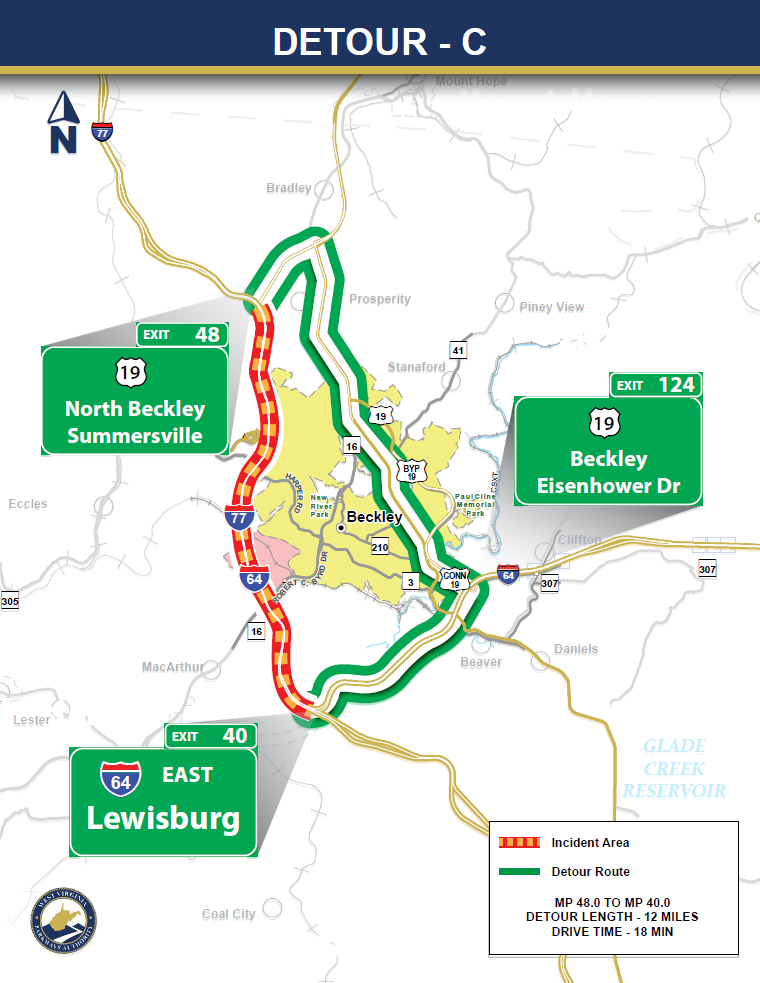
In the event of a road closure between Exits 48 and 40, traffic will be detoured to US‐19 and I‐64 to bypass the closure. For a southbound closure, I‐77 motorists will be directed to take the North Beckley Exit, and proceed north on US‐19 to the intersection with WV‐16/US‐19. Traffic will proceed south on US‐19, which is named Robert C Byrd Drive but changes to Eisenhower Drive, to the interchange with I‐ 64. Motorists will then be directed to proceed west on I‐64 until they are reconnected with I‐77. (If the incident is in the northbound lanes, drivers will follow the reverse of the route.)
Detour D (I‐77 Exit 40 to Exit 28)
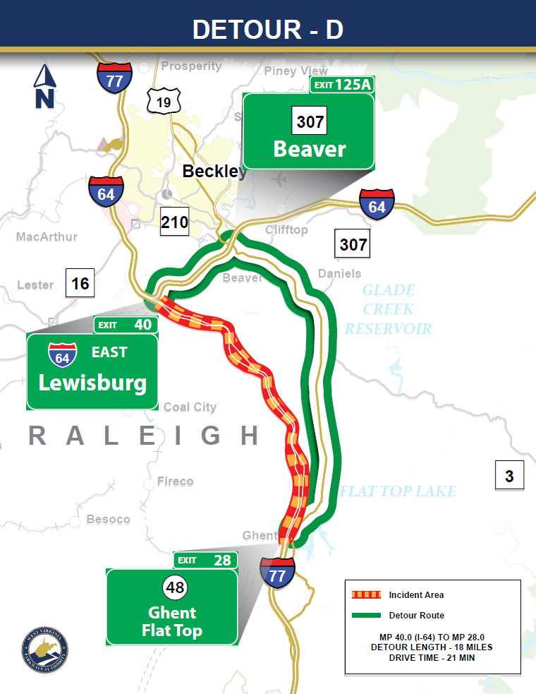
In the event of a road closure between Exits 40 and 28, traffic will be detoured along US‐19 and I‐64 to bypass the closure. For a southbound closure, I‐77 motorists will be directed to take Exit 40 which is the I‐64 eastbound exit. Drivers will proceed east on I‐64 to Exit 125A and then proceed south on WV‐307 named Airport Road to the intersection with US‐19. Drivers will then follow US‐19 south to the I‐77 intersection at Ghent. (If the incident is in the northbound lanes, drivers will follow the reverse of the route.)
Detour E (I‐77 Exit 40 to Exit 9)
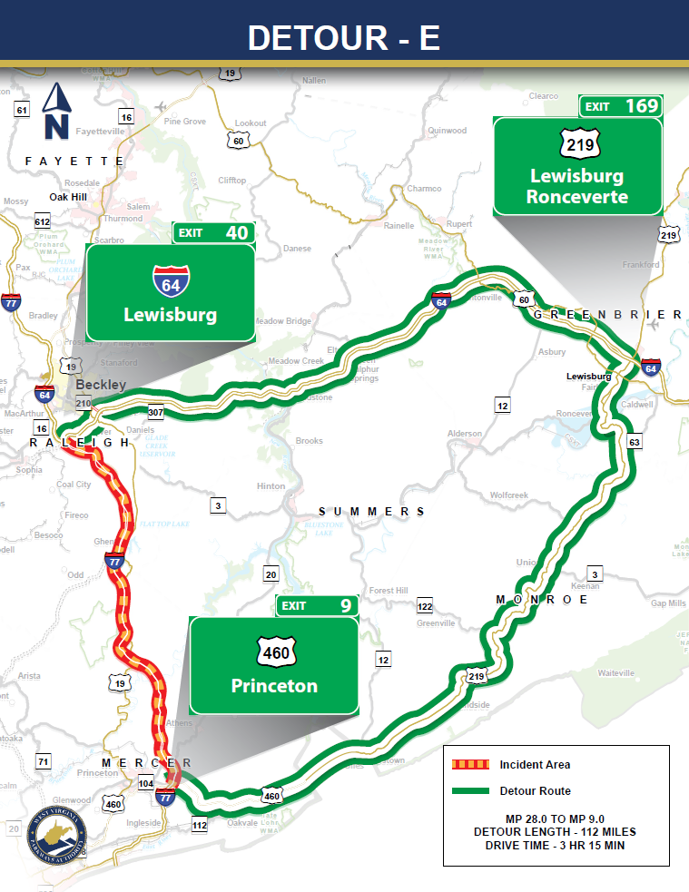
In the event of a road closure between Exits 28 and 9, traffic will be detoured along I‐64, US‐219, and US‐460 to bypass the closure. For a southbound closure, I‐77 motorists will be directed to take Exit 40 which is the I‐64 east bound exit. Drivers will proceed east on I‐64 to Exit 169 and then proceed south on US‐219 for approximately 46 miles to the intersection with US-460. Motorists will be directed west on US-460 and will continue on US-460 to the intersection with I-77. (If the incident is in the northbound lanes, drivers will follow the reverse of the route.)
Driving Safety & Information
Disabled Vehicles
- Move off the roadway if possible
- Stay with your vehicle
- Turn on your hazard lights
- Call for help using *77 on your mobile phone
- Wait for State Police or Courtesy Patrol, which conduct continuous checks
- Commercial vehicles must follow DOT regulations
Adverse Weather Tips
- Drive at speeds suitable for conditions
- Increase following distance
- Avoid driving close to large trucks
- Ensure lights and wipers work properly
- Use defrosters to keep windows clear
- Follow posted speed limits for each roadway segment
Winter Driving Tips
- Avoid driving until plows clear the roadway
- Allow extra travel time
- Keep lights and windshield clean
- Brake gently to avoid skidding
- Use low gears for traction
- Avoid cruise control
- Use caution on bridges and shaded areas
- Do not assume your vehicle can handle all conditions
Speed Limits by Mile Marker
- Milepost 9 to 60: 70 mph
- Milepost 60 to 85: 60 mph
- Milepost 85 to 93: 70 mph
- Milepost 93 to 95: 60 mph
Construction Zones
- 55 mph in a 70-mph zone
- 50 mph in a 60-mph zone
Toll Plaza Reductions
These are the posted speed limits as you approach each toll plaza. All drivers must slow to 35 mph when entering a plaza, and E‑ZPass / Pay-By-Plate lanes require a maximum speed of 5 mph.
Oversize Vehicle Requirements
A pilot car is required for loads 12 feet wide or more, longer than 75 feet, with more than 10 feet of overhang, or as determined by inspection. Overnight parking for oversized loads is not permitted at Turnpike properties.
Time restrictions for oversized vehicles vary by month.